Morocco Physical Features: Complete Geography & Terrain Guide
What are Morocco’s physical features? Morocco’s terrain runs through four mountain ranges (Rif, Middle Atlas, High Atlas, Anti-Atlas), fertile Atlantic and Mediterranean coastal plains, and the arid Sahara landscape in the south and east, all inside a country of roughly 446,550 square kilometers. Jbel Toubkal, in the High Atlas, is the highest point at 4,167 meters, while the Draa River, at about 1,100 kilometers, is the longest. Few countries this size pack in snow-capped peaks, two coastlines, and true desert within a single day’s drive of each other.
Ask someone who has never been to Morocco to describe its physical geography, and most will say one word: desert. It’s not wrong, exactly, but it’s a small fraction of the real picture. The physical geography of Morocco includes a coastline on two different seas, four separate mountain ranges (one of them snow-capped for half the year), fertile river plains that feed the country’s agriculture, and yes, a genuinely arid landscape once you cross the Atlas into the south and east. Understanding this Morocco terrain matters for more than trivia: it’s the reason a single road trip here can move you from a ski resort to a palm oasis in the same week.
We route journeys through nearly every one of these zones every month from the Rif’s green hills to the dunes of Erg Chebbi and this guide breaks down Morocco’s physical features the way we actually explain them to travelers standing at the base of the Atlas for the first time, wondering how a desert country grew mountains this big.
Table of Contents
Introduction for Morocco Physical Features:
| Feature | Detail |
|---|---|
| Total area | ~446,550 km² (172,410 sq mi), excluding the disputed Western Sahara territory |
| Highest point | Jbel Toubkal, High Atlas — 4,167 m (13,671 ft) |
| Lowest point | Sebkha Tah — around -55 m below sea level |
| Mountain ranges | Rif, Middle Atlas, High Atlas, Anti-Atlas |
| Longest river | Draa River — approximately 1,100 km |
| Coastline | Roughly 3,500 km combined, split between the Atlantic Ocean (west) and Mediterranean Sea (north) |
| Arid/desert zone | South and southeast, transitioning into the true Sahara toward Merzouga and Zagora |
| Climate zones | Mediterranean north, continental interior, alpine High Atlas, arid/desert south |
The Atlas and Rif Mountain Systems
Direct Answer: Morocco’s terrain is anchored by four mountain ranges. The Rif runs along the Mediterranean coast in the north; the Middle Atlas and High Atlas cut diagonally across the center, with the High Atlas holding Jbel Toubkal at 4,167 meters, the highest point in North Africa; and the Anti-Atlas trails off toward the southwest, forming the last mountainous barrier before the Sahara begins.
The Rif Mountains
The Rif forms a crescent-shaped range along Morocco’s Mediterranean coastline, geologically connected to Spain’s Baetic Cordillera before the two land masses separated. Most Rif peaks exceed 1,500 meters, topping out at Mount Tidirhine around 2,456 meters. The range rises abruptly from a narrow coastal plain, which is exactly why towns like Chefchaouen feel tucked into the hills rather than sprawled across flat ground.
The Middle Atlas
East and south of Fes, the Middle Atlas holds Morocco’s cedar forests, its highest concentration of natural lakes, and enough winter snowfall to support small ski areas around Ifrane and Azrou. It acts as a climate buffer, catching Atlantic moisture before it can reach the drier plateaus further southeast.
The High Atlas
The High Atlas is the backbone of Morocco’s physical geography, stretching roughly 740 kilometers from the Atlantic coast near Agadir to the Algerian border. It rises fast: from low coastal hills to peaks over 4,000 meters within a relatively short distance, which is why the drive over the Tizi n’Tichka pass between Marrakech and the desert feels like climbing through several different countries in a single afternoon.
Guide tip from Tim, our lead travel expert: “First-timers always underestimate how cold the High Atlas gets. We’ve had clients board a bus in Marrakech in a t-shirt and need a jacket two hours later at the Tizi n’Tichka pass, even in April. Pack layers whenever your route crosses the Atlas, regardless of the season.”
The Anti-Atlas
South and west of the High Atlas, the Anti-Atlas is older, lower, and more eroded, some of its rock dates back over 500 million years, among the oldest exposed geology in Morocco. Djebel Siroua, a volcanic massif within the range, reaches 3,304 meters. Past the Anti-Atlas, the mountainous terrain finally gives way to the flatter, drier expanses that lead into the Sahara.
Atlantic and Mediterranean Coastal Plains
Direct Answer: Morocco’s coastal plains stretch along roughly 3,500 kilometers of combined Atlantic and Mediterranean coastline, and they’re where most of the country’s agriculture and largest cities are concentrated. The Atlantic side includes the fertile Rharb, Chaouia, Doukkala, and Souss plains, while the Mediterranean coast is narrower and backed almost immediately by the Rif Mountains.
The Atlantic Coastal Plains
Morocco’s Atlantic coastline runs from Tangier in the north to the disputed southern territories, and its coastal plains, the Rharb around Kenitra, the Chaouia around Casablanca, the Doukkala near El Jadida, and the Souss around Agadir, hold the bulk of the country’s cereal, citrus, and vegetable farming. This is also where Morocco’s largest cities sit: Casablanca, Rabat, and Kenitra all occupy this low, fertile terrain rather than the mountains or desert most outsiders picture.
The Mediterranean Coast
North of the Rif, the Mediterranean coastline is shorter and more rugged, with the mountains dropping almost directly into the sea in places. Towns like Al Hoceima sit on narrow coastal shelves between water and steep terrain, a very different physical setting from the wide, flat Atlantic beaches near Essaouira or Agadir.
Morocco’s Arid Landscape: The Sahara and Beyond
Direct Answer: South and east of the Atlas Mountains, Morocco’s terrain shifts into a genuinely arid landscape, first semi-arid steppe and rocky hamada plateau, then true Saharan dunes around Merzouga and Erg Chebbi. This transition, not an instant wall of sand, is one of the most misunderstood parts of Morocco’s physical geography.
From Semi-Arid Plateau to True Desert
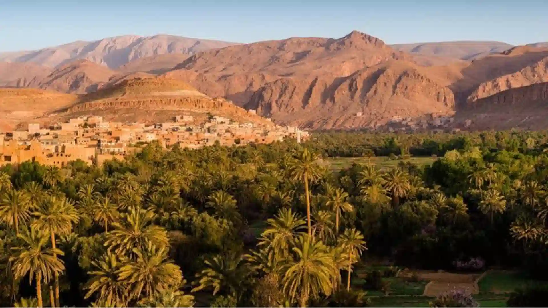
The land immediately south of the Atlas isn’t sand dunes, it’s rocky hamada plateau and scrubby pre-Saharan steppe, dotted with palm oases fed by underground water and seasonal river valleys like the Draa and Ziz. True sand-sea desert, the kind travelers picture when they hear “Sahara,” is concentrated in specific pockets, most famously Erg Chebbi near Merzouga and Erg Chigaga near M’Hamid, rather than covering the entire south uniformly.
Why Morocco’s Arid Zone Feels So Different from Region to Region
Elevation and water access change the character of Morocco’s arid landscape dramatically over short distances. A palm oasis in the Draa Valley can sit within sight of bare, sun-baked hamada rock; a river-fed town like Zagora depends entirely on underground aquifers and seasonal flooding that a dune field ten kilometers away never sees. This patchwork, rather than uniform sand, is what makes multi-day desert routes visually varied instead of repetitive.
Guide tip from Amin, our Amazigh-language and southern-route specialist: “People expect the desert to look the same the whole way from Ouarzazate to Merzouga. It doesn’t. You pass through at least four completely different terrains in one day: mountains, gorges, hamada plateau, and finally the dunes. Watching that change is half the reason the drive is worth it on its own.”
Rivers and Water Features
Direct Answer: Morocco’s major rivers, the Draa, Sebou, Oum Er-Rbia, Moulouya, and Bou Regreg, all originate in the Atlas or Rif mountains and either feed the Atlantic coastal plains or, in the Draa’s case, run seasonally dry as they push toward the desert. These rivers explain why Morocco’s oases and farmland cluster exactly where they do.
| River | Length | Source & Character |
|---|---|---|
| Draa | ~1,100 km | Morocco’s longest river; High Atlas source, runs seasonally dry toward the Atlantic near Tan-Tan |
| Sebou | ~496 km | Middle Atlas source; Morocco’s highest-volume river, feeds the fertile Rharb plain |
| Oum Er-Rbia | ~555 km | Middle Atlas source; second-highest volume, irrigates the Doukkala and Chaouia plains |
| Moulouya | ~450 km | Middle Atlas source; flows northeast to the Mediterranean, marking part of the Algeria border zone |
| Bou Regreg | ~240 km | Short Atlantic river separating Rabat and Salé at its estuary |
Morocco Terrain by Region: Head-to-Head
| Region | Dominant Terrain | Elevation Range | Best Known For |
|---|---|---|---|
| Rif (north) | Steep coastal mountains | Sea level – 2,456 m | Chefchaouen, cedar and pine forest |
| Atlantic plains | Flat, fertile coastal lowland | Sea level – 300 m | Casablanca, Rabat, agriculture |
| Middle Atlas | Forested mid-elevation mountains, lakes | 1,000 m – 3,340 m | Ifrane, cedar forests, winter snow |
| High Atlas | High alpine peaks and passes | 1,000 m – 4,167 m | Jbel Toubkal, Tizi n’Tichka pass |
| Anti-Atlas & pre-Sahara | Eroded hills, hamada plateau | 400 m – 3,304 m | Ancient rock formations, kasbah routes |
| Sahara (south/east) | Sand dunes, arid desert | Below sea level – 500 m | Erg Chebbi, Erg Chigaga, palm oases |
How Terrain Shapes Morocco’s Climate Zones
Direct Answer: Morocco’s mountain ranges act as climate walls, holding Mediterranean-influenced weather along the north and Atlantic coasts, catching moisture in the Middle Atlas, and leaving the land south and east of the High Atlas in a rain shadow that produces the country’s arid and desert conditions.
Why the High Atlas Creates a Rain Shadow
The High Atlas runs roughly east-west across the middle of the country, which means it directly intercepts moist air moving in from the Atlantic. Rain and snow fall on the range’s northern and western slopes, feeding the rivers that irrigate Marrakech’s plains, while the southern side, facing the Sahara, receives a fraction of that rainfall. This single mountain wall is the main reason Morocco’s climate can shift from alpine to desert within a two-hour drive.
Four Climate Zones in One Country
- Mediterranean north: Mild, wetter winters and warm dry summers along the Rif and northern coast.
- Continental interior: Hotter summers and colder winters across the central plateaus and Middle Atlas.
- Alpine High Atlas: Snow-capped peaks with skiing conditions from roughly December through March.
- Arid/desert south: Minimal rainfall, extreme day-to-night temperature swings, concentrated around the Draa Valley and Sahara routes.
Why Morocco’s Physical Geography Matters for Your Trip
Direct Answer: Every multi-day tour we build is a direct response to Morocco’s terrain, the mountain passes, river valleys, and desert transitions determine which roads exist, how long a route realistically takes, and what to pack, which is exactly why route planning here isn’t just picking cities on a map.
At Over Morocco Tours, our itineraries are built around the physical geography most guides skim past. The Tizi n’Tichka pass across the High Atlas isn’t just scenery, it’s the reason a Marrakech-to-Merzouga desert route takes a full day of driving rather than a few hours in a straight line. The Draa Valley’s palm oases aren’t random stops, they follow the river’s course because that’s the only water source for hundreds of kilometers in either direction. Understanding Morocco’s terrain isn’t academic for us; it’s the raw material every itinerary is built from.
- Marrakech to Merzouga desert routes cross all four terrain zones in a single multi-day trip: High Atlas mountains, Anti-Atlas foothills, hamada plateau, and true Saharan dunes.
- Chefchaouen and Rif routes move through the steep coastal mountain terrain that gives northern Morocco its cooler, greener character compared to the south.
- Draa Valley and Zagora itineraries follow the river’s oasis line directly, the same water-driven settlement pattern that has shaped this route for centuries.
- Middle Atlas detours through Ifrane and the cedar forests offer a genuinely different Morocco: cooler air, pine forest, and, in winter, snow, a useful contrast for travelers who only picture desert.
If your interest in Morocco’s physical geography is really about planning where to go, our team can turn any of these terrain zones into an actual route, timed around the passes, water stops, and seasonal conditions that maps alone don’t show.
Frequently Asked Questions
What are Morocco’s main physical features?
Morocco’s main physical features are four mountain ranges (Rif, Middle Atlas, High Atlas, and Anti-Atlas), Atlantic and Mediterranean coastal plains, and the arid Sahara in the south and east. Jbel Toubkal, in the High Atlas, is the highest point at 4,167 meters.
What is the physical geography of Morocco like?
Morocco’s physical geography runs from Mediterranean and Atlantic coastlines through fertile plains and plateaus, up over four Atlas and Rif mountain chains, and down into the arid Sahara, all within a country covering roughly 446,550 square kilometers.
Is most of Morocco desert?
No. True Saharan desert covers the south and southeast, but northern and central Morocco include Mediterranean coastline, fertile Atlantic plains, and snow-capped mountains. Arid and semi-arid terrain still makes up a large share of the country’s total land area.
What is the highest point in Morocco?
Jbel Toubkal, in the High Atlas range about 63 kilometers south of Marrakech, is Morocco’s highest point at 4,167 meters. It is also the highest peak in North Africa and the wider Arab world.
What is the longest river in Morocco?
The Draa River is Morocco’s longest at roughly 1,100 kilometers. It forms in the High Atlas from the Dades and Imini rivers and flows toward the Atlantic near Tan-Tan, though its lower course runs dry for most of the year.
How many mountain ranges does Morocco have?
Morocco has four mountain ranges: the Rif in the north, and the Middle Atlas, High Atlas, and Anti-Atlas running roughly northeast to southwest through the center and south of the country.
Does Morocco have both mountains and desert terrain?
Yes. Morocco is unusual in having snow-capped mountains, Mediterranean and Atlantic coastline, and true Sahara desert terrain all within driving distance of each other, which is why cross-country tours can move between all three in under a week.
The Takeaway: Morocco’s Physical Features
Morocco packs an unusual range of terrain into one country: two coastlines, four mountain ranges, fertile river plains, and a genuinely arid Saharan landscape, all within a day or two’s drive of each other. That density of physical features is exactly what makes Morocco such a compressed, varied place to travel through, and exactly what every route on this site is built around. Whatever drew you to look up Morocco’s physical geography, whether it’s a school project, a documentary, or a trip you’re actually planning, the terrain itself is the story: mountains built the culture’s isolation and diversity, rivers built its farmland and oases, and the desert built the trade routes that shaped its history.
Related Guides to Morocco’s Geography and Terrain
- What Language Do They Speak in Morocco?
- Is Marrakech or Casablanca More Beautiful?
- Morocco’s Imperial Cities: The Complete Guide
Sources referenced: Wikipedia — Geography of Morocco, Encyclopaedia Britannica — Morocco: Relief, and Wikipedia — Atlas Mountains. Elevation and length figures are commonly cited approximations; always confirm current figures with official sources if precision matters for your use case.